Russian Topo Maps Pro
by ATLOGIS Geoinformatics GmbH & Co. KG
Version 50,000+ 💾 3 Mb
📅 Updated Eligible if bought after 7/2/2016.
Learn
Worldwide Topographic Maps 1:100.000-1:200.000 - OFFLINE USAGE !
Features Russian Topo Maps Pro
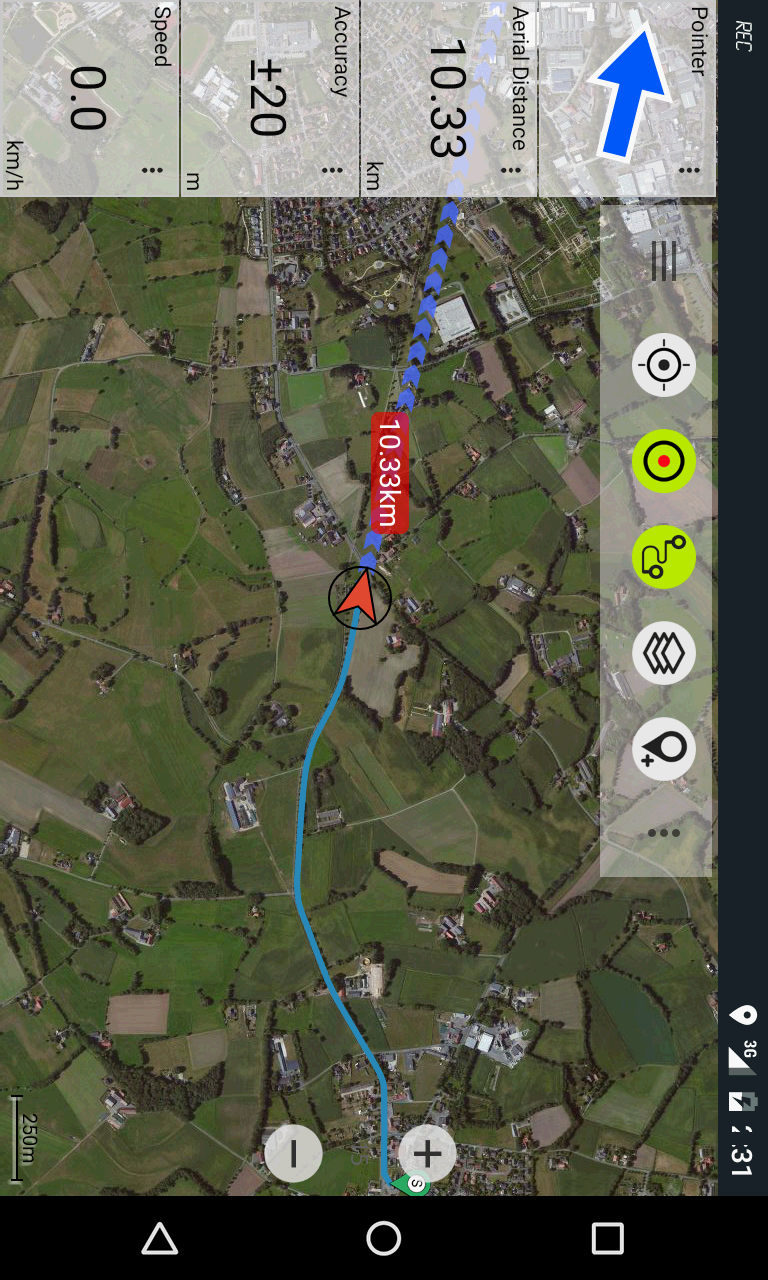
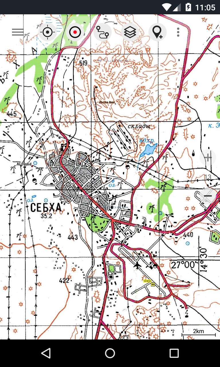
Offroad/Offline Navigation App with worldwide topographic maps (mainly Russian General Staff).
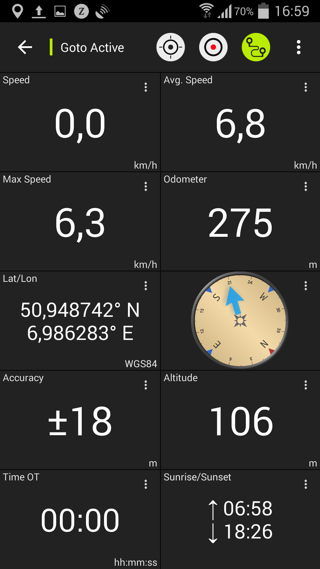
For many countries in Africa and Asia these maps still belong to the best available topomaps.Available map layers:• Topomaps worldwide (100K-200K worldwide seamless coverage)• Google Maps (Satellite images, Road- and Terrain-Map)• ROSREESTR The Federal Service for State Registration, Cadastre and Cartography• Open Street Maps (OSM Mapnik, Osmarender and Cloudemade Cyclemap)• Bing Maps• Hillshading Overlay Layer• ESRIThis app gives you similar mapping options as you might know from Garmin or Magellan GPS handhelds.Main features for Outdoor-Navigation:• Bulk-download of map tiles for OFFLINE USAGE (not for Google maps)• Create and edit Waypoints• Create and navigate Routes• GoTo-Waypoint-Navigation• Track Recording (with speed and elevation profile)• Tripmaster with fields for odometer, average speed, bearing, elevation, etc.
• GPX-Import / Export, KML-Export• Search (placenames, POIs, streets)• Customizable datafields in Map View and Tripmaster (e.g.
Speed, Distance, Compass, ...)• Waypoint-/Track-Sharing (via eMail, Facebook, ..)• Import Oziexplorer raster map in with OZF2 OZFX3 extension• Import OpenStreetMaps in vector format (less storage needed)• and many more ...Soviet Military Maps is the perfect moving map app for offroad trips, adventure travels and expeditions.
You are planning cross country trips to Sahara desert or a trekking tour to the Himalayas ?
With the Russian topos you have always a great alternative to other map sources.
Beneath the good topography the maps include many small trails and unpaved roads that are missing in other map sets.The Russian maps have additional English labels.Attention: The Soviet Military Maps were created mainly in the 80ies and are less interesting for industrialized countries.
Outside Africa and Asia youll find the OSM / Google map layers more useful.Please note: This app does not provide direct "Turn-by-Turn" navigation - but with a selected waypoint you can easily switch to Google Navigation.Please contact us if you have any questions, feature requests or bug reports regarding this app: [email protected] coverage: Scale 1:100.000 :Europe, Afghanistan, Azerbaijan, Georgia, Japan, Jordan, Latvia, Lithuania, Kazakhstan, Kyrgyzstan, Morocco, Mongolia, Pakistan, Russia, Syria, Tajikistan, Turkey, Turkmenistan, Ukraine, Uzbekistan, BelarusScale 1:200.000 :Afghanistan, Egypt, Algeria, Angola, Argentina, Armenia, Azerbaijan, Bahrain, Bangladesh, Belarus, Benin, Bhutan, Bolivia, Botswana, British Virgin Islands, Bulgaria, Burkina Faso, Burma, Cambodia, Cameroon, Central African Republic, Chad, Chile, China, Comoros, Ivory Coast, Cuba, Cyprus, Czech Republic, DR Congo (part), Djibouti, Eritrea, Estonia, Ethiopia, Falkland Islands, Finland, Gambia, Georgia, Ghana, Guinea, Guinea-Bissau, Iceland, India, Indonesia, Iran, Iraq, Israel, Jamaica, Jordan, Kazakhstan, Kenya (part), Kuwait, Kyrgyzstan, Laos, Latvia, Lebanon, Lesotho, Liberia, Libya, Lithuania, Madagascar, Malawi, Malaysia, Mali, Mauritania, Moldova, Mongolia , Morocco, Mozambique, Namibia, Nepal, Niger, Nigeria, North Korea, Oman, Pakistan, Philippines, Qatar, Romania, Russia, Saudi Arabia, Senegal, Sierra Leone, Singapore, Slovakia, Somalia, South Africa, South Korea, Spain, Sri Lanka , Sudan, Svalbard, Swaziland, Sweden, Syria, Taiwan, Tajikistan, Tanzania (part), Thailand, The Gambia, Togo, Tunisia, Turkey, Turkmenistan, Ukraine, United Arab Emirates, Uzbekistan, Vietnam, Western Sahara, Yemen, Zambia, ZimbabweScale 1:250.000 (Local maps from USGS, Geoscience Australia, CTIO ):USA, Canada, AustraliaScale 1:500.000:All other countries
Social Features
Connect and share with friends and the community.
Fitness Tracking
Track your workouts and monitor your health metrics.
Travel Features
Plan and manage your travels with ease.
See the Russian Topo Maps Pro in Action
What Our Users Say
Don't just take our word for it. Here's what our users have to say about our Android app.
"A super app.; very well laid out and a marvel to use!"
Vir Maximi Animi
"Very good. You have to put in the time learning topo maps apps, but once you do you won't need anything else accept your paper backups. I always carry paper maps when going into an unknown region."
azdesert survival primitive expert
"realy one of the best apps in this category"
Franciscus van Geenen
"Best application"
Amine Bousbia
"Спасибо за отличное приложение! Протестировано геодезистом! Очень помогает в работе! После того как добавили границы кадастровые прям все 6 баллов из 5!"
What What
"Nice app, i love it"
Nuzul e&
"Awesome"
Jan Buhrmann
"Excellent"
Clive Sani
"Good app"
Lee Muda
"I am using it for my backpacking trips in Siberia for a number of years. It is very useful for navigating in unknown areas especially if you did not prepare a trip plan in advance and have no GPS cooddinates for key points. Just do not forget to download maps for the area of interest."
Alexander Nikitin
Get the App Today
Available for Android 8.0 and above